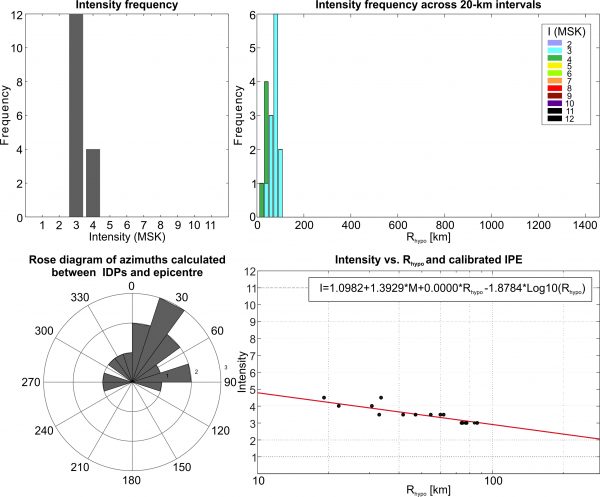
This earthquake occurred on 06/03/1968 at 03:01 UTC. It has a given magnitude of 3.7 Ms (4.6 Mw) and an hypocentral depth of 24 km. The fault associated with the earthquake is the Gori fault (Ref..). The IDPs range from 3 to 5 (MSK) and are all located in Georgia.

Stats
IDPs number: 24; Areal extent (WGS84): (41.697-42.521°N; 43.411-44.832°E); Rhypo range (km): 24-81.
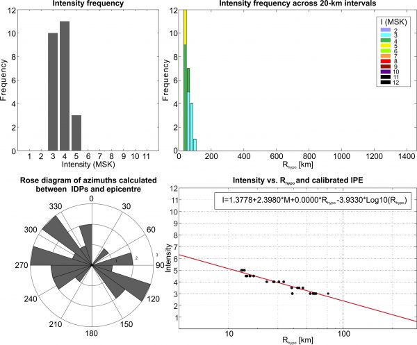
This earthquake occurred on 19/06/1968 at 15:03 UTC. It has a given magnitude of 4.0 Ms (4.8 Mw) and an hypocentral depth of 10 km (Ref..). The fault associated with the earthquake is the Agricari W fault (Ref..). The IDPs range from 3 to 4-5 (MSK) and are located all in Georgia.
Stats
IDPs number: 16; Areal extent (WGS84): (41.267-42.021°N; 43.488-44.832°E); Rhypo range (km): 19-86.
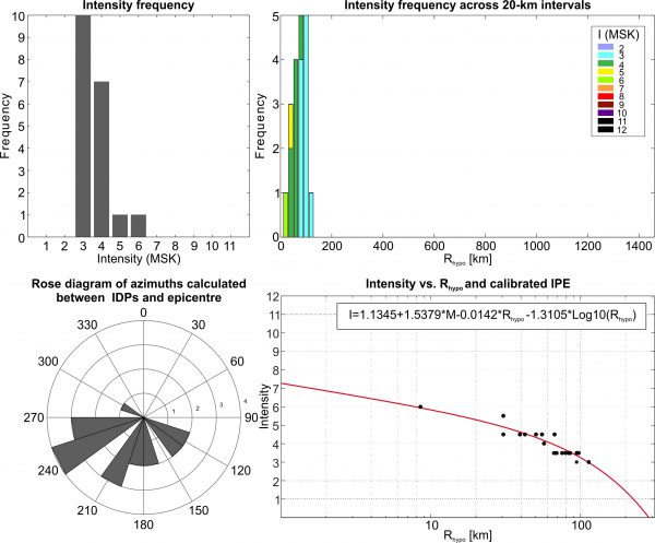
This earthquake occurred on 14/06/1969 at 17:44 UTC. It has a given magnitude of 4.6 Ms (5.2 Mw) and an hypocentral depth of 12 km (Ref..). The fault associated with the earthquake is the Madatapa fault (Ref..). The IDPs range from 3-4 to 5-6 (MSK) and are located between Georgia and northern Armenia.
Stats
IDPs number: 20; Areal extent (WGS84): (41.033-42.021°N; 42.843-44.832°E); Rhypo range (km): 13-115.
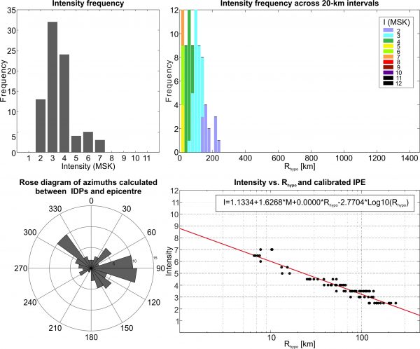
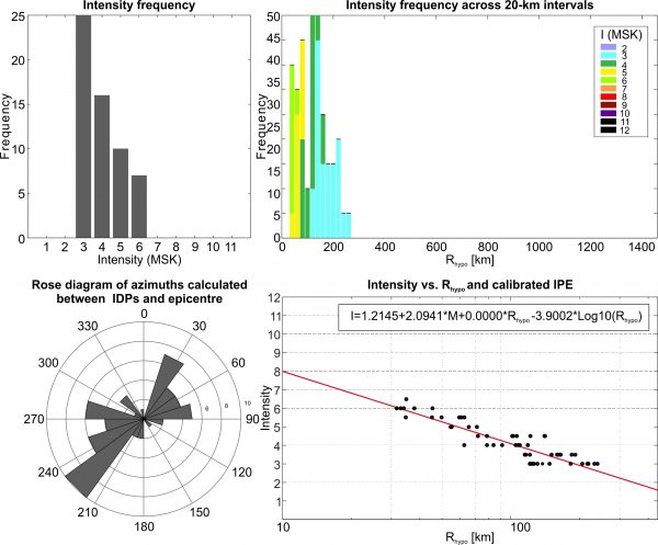
This earthquake occurred on 03/01/1970 at 06:54 UTC. It has a given magnitude of 4.7 Ms (5.2 Mw) and an hypocentral depth of 5 km. The fault associated with the earthquake is the Tba fault. The IDPs range from 2-3 to 7 (MSK) and are located between Georgia and northern Armenia.
Stats
IDPs number: 81; Areal extent (WGS84): (41.874-42.649°N; 41.874-46.275°E); Rhypo range (km): 7-240.
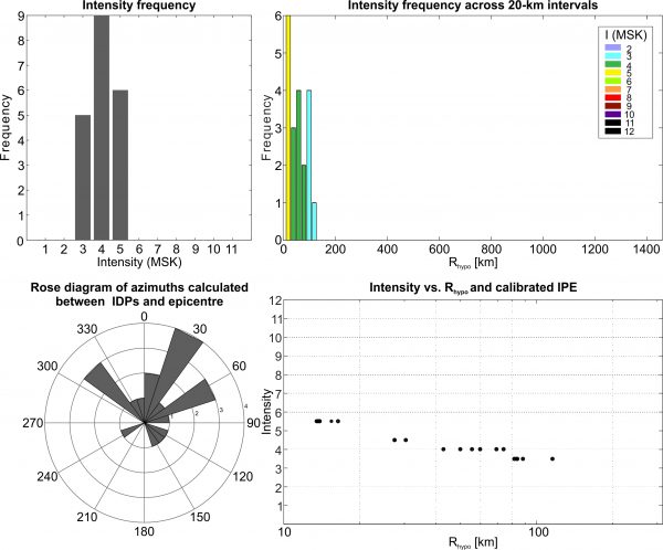
This earthquake occurred on 28/06/1971 at 19:53 UTC. It has a given magnitude of 4.0 Ms (4.8 Mw) and an hypocentral depth of 7 km (Ref..). The fault associated with the earthquake is the Ambrolauri E fault (Ref..). The IDPs range from 3 to 6 (MSK) and are located all in Georgia.
Stats
IDPs number: 19; Areal extent (WGS84): (41.707-42.789°N; 42.379-44.487°E); Rhypo range (km): 9-113.
This earthquake occurred on 08/09/1971 at 22:35 UTC. It has a given magnitude of 4.5 Ms (5.1 Mw) and an hypocentral depth of 12 km (Ref..). The fault associated with the earthquake is the Agricari W fault (Ref..). The IDPs range from 3 to 6 (MSK) and are located between Georgia and northern Armenia.
Stats
IDPs number: 64; Areal extent (WGS84): (40.992-42.152°N; 42.843-44.832°E); Rhypo range (km): 13-106.
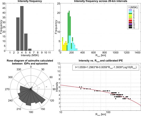
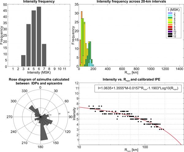
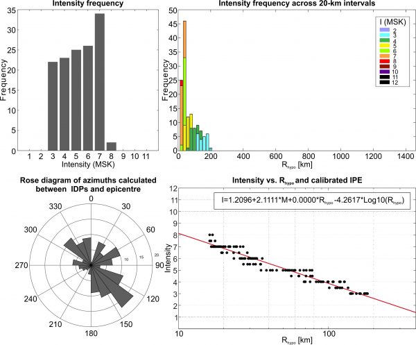
This earthquake occurred on 13/05/1986 at 08:44 UTC. It has a given magnitude of 5.6 Ms (5.8 Mw) and an hypocentral depth of 12 km (Ref..). The fault associated with the earthquake is the Samsari fault (Ref..). The IDPs range from 3 to 7-8 (MSK) and are all located in Georgia, Armenia and Azerbaijan.
Stats
IDPs number: 154; Areal extent (WGS84): (40.150-42.789°N; 42.010-45.974°E); Rhypo range (km): 14-190.
This earthquake occurred on 04/08/1974 at 15:06 UTC. It has a given magnitude of 5.1 Ms (5.5 Mw) and an hypocentral depth of 18 km (Ref..). The fault associated with the earthquake is the Malkamud W fault (Ref..). The IDPs range from 3 to 6-7 (MSK) and are located between Georgia, Armenia and Russia.
Stats
IDPs number: 58; Areal extent (WGS84): (40.750-43.312°N; 42.997-47.321°E); Rhypo range (km): 32-240.
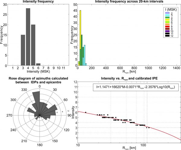
This earthquake occurred on 02/01/1978 at 06:31 UTC. It has a given magnitude of 5.3 Ms (5.6 Mw) and an hypocentral depth of 18 km (Ref..). The fault associated with the earthquake is the Dmanisi NW fault (Ref..). The IDPs range from 3 to 8 (MSK) and are located between Georgia, Armenia and Azerbaijan.
Stats
IDPs number: 132; Areal extent (WGS84): (40.150-42.649°N; 42.085-45.917°E); Rhypo range (km): 16-182.
This earthquake occurred on 26/05/1978 at 13:43 UTC. It has a given magnitude of 4.3 Ms (5.0 Mw) and an hypocentral depth of 10 km (Ref..). The fault associated with the earthquake is the Boshuri fault (Ref..). The IDPs range from 3 to 6 (MSK) and are located all in Georgia and northern Armenia.
Stats
IDPs number: 102; Areal extent (WGS84): (39.508-42.950°N; 42.988-48.500°E); Rhypo range (km):25-292.