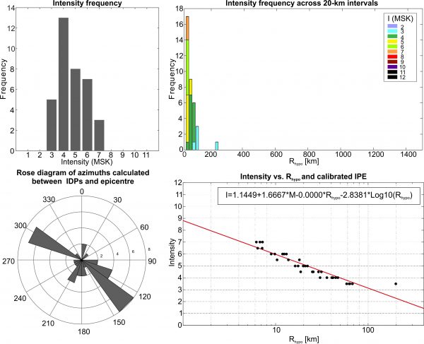
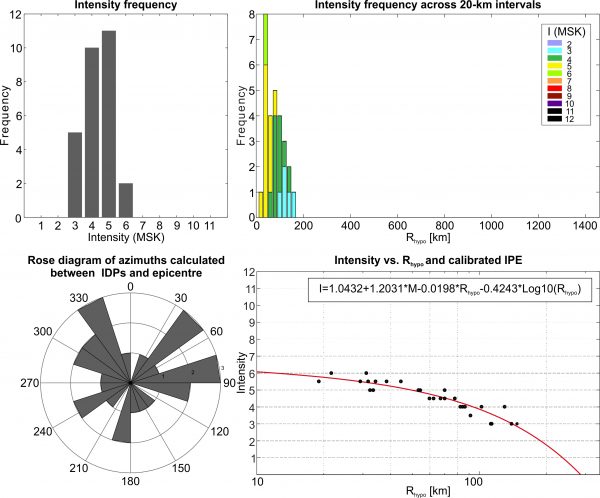
This earthquake occurred on 13/05/1968 at 02:46 UTC. It has a given magnitude of 4.5 Ms (5.1 Mw) and an hypocentral depth of 15 km. The fault associated with the earthquake is the Ritsa C fault (Ref..). The IDPs range from 3 to 6-7 (MSK) and are located between western Georgia and Russia.
Stats
IDPs number: 21; Areal extent (WGS84): (42.414-43.680°N; 39.727-42.379°E); Rhypo range (km): 9-189.
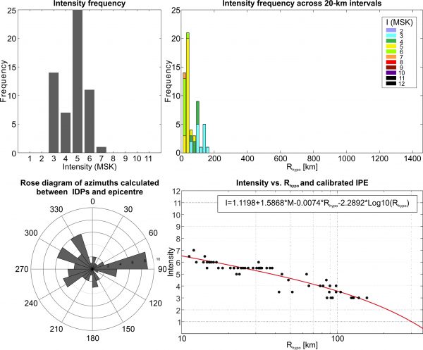
This earthquake occurred on 05/07/1958 at 02:05 UTC. It has a given magnitude of 4.6 Ms (5.2 Mw) and an hypocentral depth of 6 km (Ref..). The fault associated with the earthquake is the Gudava fault (Ref..). The IDPs range from 3-4 to 7 (MSK) and are all located in Georgia.
Stats
IDPs number: 36; Areal extent (WGS84): (41.416-42.984°N; 40.978-43.340°E); Rhypo range (km): 6-200.
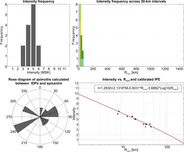
This earthquake occurred on 23/02/1981 at 04:06 UTC. It has a given magnitude of 4.9 Ms (5.4 Mw) and an hypocentral depth of 10 km (Ref..). The fault associated with the earthquake is the Velistsikhe fault (Ref..). The IDPs range from 3 to 7 (MSK) and are located between eastern Georgia, Armenia and Azerbaijan.
Stats
IDPs number: 58; Areal extent (WGS84): (40.992-42.129°N; 44.378-46.650°E); Rhypo range (km): 11-155.
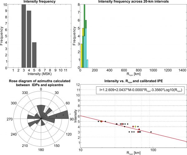
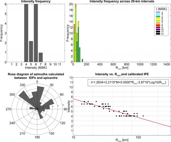
This earthquake occurred on 24/01/1982 at 02:03 UTC. It has a given magnitude of 4.0 Ms (4.8 Mw) and an hypocentral depth of 11 km (Ref..). The fault associated with the earthquake is the Gomi fault (Ref..). The IDPs range from 3 to 5 (MSK) and are all located in Georgia.
Stats
IDPs number: 23; Areal extent (WGS84): (41.639-42.585°N; 42.699-44.487°E); Rhypo range (km): 18-94
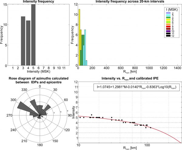
This earthquake occurred on 19/01/1984 at 09:21 UTC. It has a given magnitude of 4.0 Ms (4.8 Mw) and an hypocentral depth of 10 km (Ref..). The fault associated with the earthquake is the Mada E fault (Ref..). The IDPs range from 3 to 5-6 (MSK) and are all located in Georgia and northern Armenia.
Stats
IDPs number: 38; Areal extent (WGS84): (41.000-42.111°N; 42.832-44.832°E); Rhypo range (km): 11-110.
This earthquake occurred on 31/05/1958 at 03:50 UTC. It has a given magnitude of 4.7 Ms (5.2 Mw) and an hypocentral depth of 17 km (Ref..). The fault associated with the earthquake is the Javakheti fault (Ref..). The IDPs range from 3 to 6 (MSK) and are all located between Georgia and Armenia.
Stats
IDPs number: 28; Areal extent (WGS84): (40.150-42.519°N; 42.988-44.808°E); Rhypo range (km): 19-148.
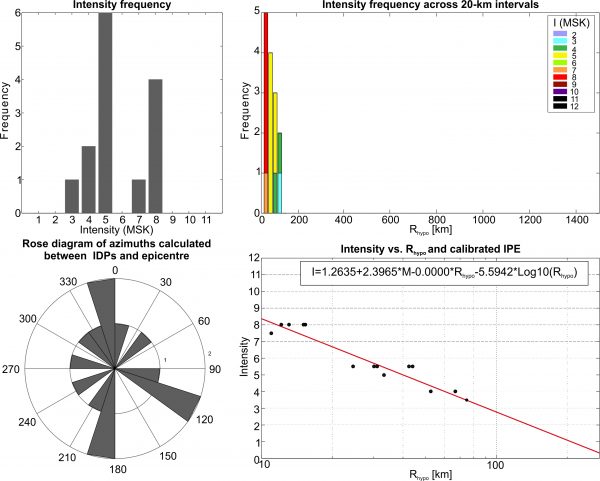
This earthquake occurred on 29/01/1957 at 15:21 UTC. It has a given magnitude of 5.3 Ms (5.6 Mw) and an hypocentral depth of 11 km (Unpublished instrumental data. Archives of the TSU M. Nodia Institute of Geophysics). The IDPs range from 3-4 to 8 (MSK) and are all located in Georgia.
Stats
IDPs number: 14; Areal extent (WGS84): (42.141-42.849°N; 41.675-42.997°E); Rhypo range (km): 11-75.
This earthquake occurred on 25/12/1955 at 18:43 UTC. It has a given magnitude of 4.8 Ms (5.3 Mw) and an hypocentral depth of 10 km (Unpublished instrumental data. Archives of the TSU M. Nodia Institute of Geophysics). The IDPs range from 3 to 6-7 (MSK) and are all located in Georgia.
Stats
IDPs number: 36; Areal extent (WGS84): (41.707-43.051°N; 41.467-43.531°E); Rhypo range (km): 17-150.
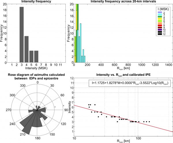
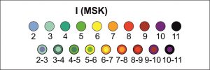
This earthquake occurred on 11/06/1954 at 11:25 UTC. It has a given magnitude of 4.6 Ms (5.2 Mw) and an hypocentral depth of 12 km (Kondorskaya and Shebalin, 1982). The IDPs range from 4 to 7 (MSK) and are all located between Georgia and northern Armenia.
Stats
IDPs number: 63; Areal extent (WGS84): (41.000-42.152°N; 42.951-45.162°E); Rhypo range (km): 14-120.
TThis earthquake occurred on 12/02/1953 at 07:46 UTC. It has a given magnitude of 4.0 Ms (4.8 Mw) and an hypocentral depth of 7 km (Varazanashvili, 2017). The IDPs range from 3-4 to 6-7 (MSK) and are all located in Georgia.
Stats
IDPs number: 14; Areal extent (WGS84): (41.600-42.021°N; 43.443-44.340°E); Rhypo range (km): 8-43.