Logo unimib Logo centro di ricerca

  • Home
  • Participants
  • Reports and publications
  • About Georgia
  • Contacts
  • The project

    • Project description
    • Project Leaders
    • Project Co-Leaders
    • End-users
    • Partner Overviews
    • Missions, Meetings and Conferences
    • Training schools
  • Our previous NATO project

    • Our previous NATO publications (2004-2015)
    • Our previous NATO projects
  • 1940 M 5.1 Aftershock of Tabatskuri earthquake (1940.07101310)

    Macroseismic Catalogue of Georgia

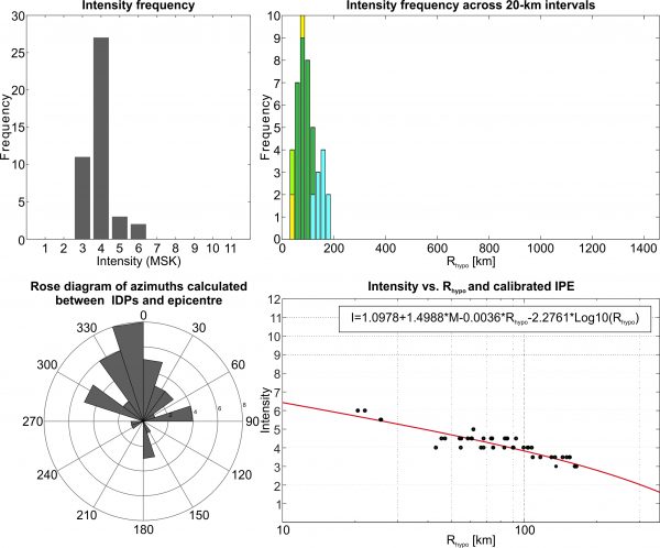
    This earthquake occurred on 10/07/1940 at 13:10 UTC. It has a given magnitude of 5.1 Ms (5.5 Mw) and an hypocentral depth of 18 km (Kondorskaya and Shebalin, 1982). The IDPs range from 3 to 6 (MSK) and are all located between Georgia, Azerbaijan and Armenia.


    Stats
    IDPs number: 43; Areal extent (WGS84): (40.792-42.645°N; 42.033-45.242°E); Rhypo range (km): 20-165.

  • News and media

    • The project on air
    • Media coverage
    • Pictures
    • Video clips
  • GeoInt Database

    • Introduction
    • Online Catalogue
    • Download Data
    • References
    • Alessandro Tibaldi
    • Francesca Balbi
    • Fabio Bonali
    • Paolo Iannuccelli
    • Patrizia Scapinelli
    Questo sito utilizza i cookie per fornire alcuni servizi e migliorare l'esperienza utente, potrebbero inoltre essere inviati cookie di terze parti. Per saperne di più consultare le note sulla privacy alla sezione "cookies". OkNote sulla privacy