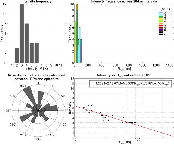
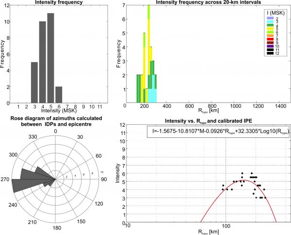
This earthquake occurred on 02/11/1951 at 21:55 UTC. It has a given magnitude of 5.3 Ms (5.6 Mw) and an hypocentral depth of 16 km (Kondorskaya and Shebalin, 1982). The IDPs range from 3-4 to 6-7 (MSK) and are located between Georgia, Armenia, Azerbaijan and Russia.

Stats
IDPs number: 89; Areal extent (WGS84): (40.150-42.654°N; 42.258-46.965°E); Rhypo range (km): 19-251.
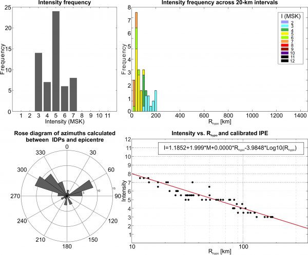
This earthquake occurred on 03/03/1951 at 21:41 UTC. It has a given magnitude of 4.6 Ms (5.2 Mw) and an hypocentral depth of 14 km (Varazanashvili, 2017). The IDPs range from 3 to 6 (MSK) and are located between Georgia and Armenia.
Stats
IDPs number: 49; Areal extent (WGS84): (40.792-43.325°N; 42.997-45.667°E); Rhypo range (km): 14-190.
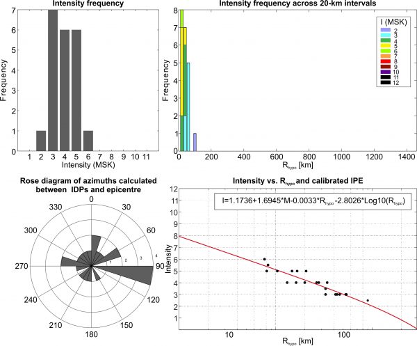
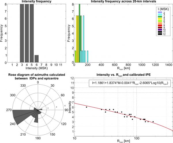
This earthquake occurred on 17/01/1951 at 00:21 UTC. It has a given magnitude of 4.2 Ms (4.9 Mw) and an hypocentral depth of 16 km (Kondorskaya and Shebalin, 1982). The IDPs range from 3-4 to 6 (MSK) and are located between Georgia and Armenia.
Stats
IDPs number: 24; Areal extent (WGS84): (40.658-42.021°N; 42.832-44.900°E); Rhypo range (km): 16-124.
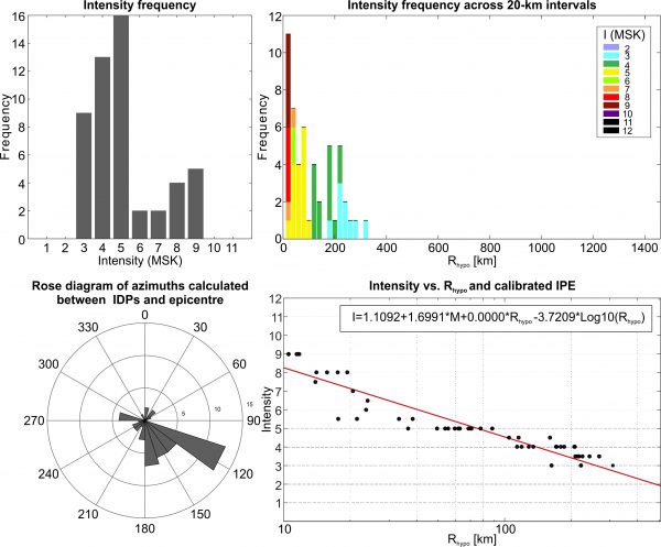
This earthquake occurred on 26/11/1958 at 00:12 UTC. It has a given magnitude of 4.6 Ms (5.2 Mw) and an hypocentral depth of 19 km (Ref..). The fault associated with the earthquake is the Dedophlistskaro fault (Ref..). The IDPs range from 3 to 6 (MSK) and are all located between Georgia and Armenia.
Stats
IDPs number: 28; Areal extent (WGS84): (40.150-42.519°N; 42.988-44.808°E); Rhypo range (km): 93-249.
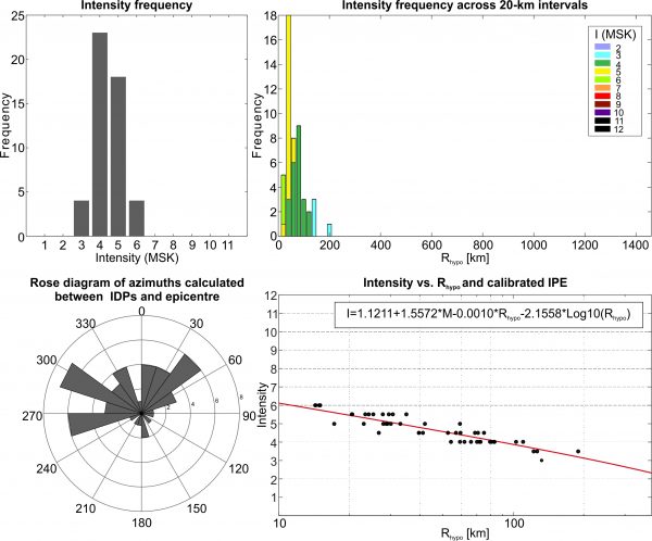
This earthquake occurred on 08/12/1959 at 13:33 UTC. It has a given magnitude of 5.4 Ms (5.7 Mw) and an hypocentral depth of 10 km (Ref..). The fault associated with the earthquake is the Madatapa fault (Ref..). The IDPs range from 3 to 7-8 (MSK) and are all located between Georgia and Armenia.
Stats
IDPs number: 59; Areal extent (WGS84): (40.150-42.649°N; 41.854-45.923°E); Rhypo range (km): 12-185.
This earthquake occurred on 20/05/1959 at 19:49 UTC. It has a given magnitude of 5.1 Ms (5.5 Mw) and an hypocentral depth of 9 km (Ref..). The fault associated with the earthquake is the Natanebi W fault (Ref..). The IDPs range from 3 to 7-8 (MSK) and are all located in Georgia.
Stats
IDPs number: 84; Areal extent (WGS84): (41.409-43.106°N; 40.634-44.832°E); Rhypo range (km): 9-248.

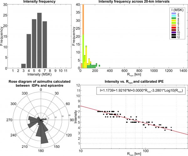
This earthquake occurred on 16/07/1963 at 18:27 UTC. It has a given magnitude of 6.4 Ms (6.4 Mw) and an hypocentral depth of 10 km (Ref..). The fault associated with the earthquake is the Ptish fault (Ref..). The IDPs range from 3 to 9 (MSK) and are all located between Georgia and Russia.
Stats
IDPs number: 51; Areal extent (WGS84): (41.643-43.913°N; 39.717-44.832°E); Rhypo range (km): 11-309
This earthquake occurred on 17/06/1967 at 09:56 UTC. It has a given magnitude of 4.0 Ms (4.8 Mw) and an hypocentral depth of 7 km (Ref..). The fault associated with the earthquake is the Taurtepe NW fault (Ref..). The IDPs range from 2-3 to 6 (MSK) and are all located in Georgia.
Stats
IDPs number: 21; Areal extent (WGS84): (41.464-42.111°N; 44.113-45.798°E); Rhypo range (km): 8-180.
This earthquake occurred on 11/03/1964 at 00:08 UTC. It has a given magnitude of 4.5 Ms (5.1 Mw) and an hypocentral depth of 14 km (Ref..). The fault associated with the earthquake is the Aragvi E fault (Ref..). The IDPs range from 3 to 6 (MSK) and are all located in Georgia.
Stats
IDPs number: 25; Areal extent (WGS84): (41.697-42.560°N; 42.843-45.483°E); Rhypo range (km): 16-185.
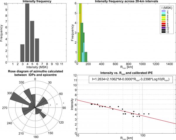
This earthquake occurred on 29/06/1967 at 08:22 UTC. It has a given magnitude of 4.4 Ms (5.0 Mw) and an hypocentral depth of 10 km (Ref..). The fault associated with the earthquake is the Javakheti fault (Ref..). The IDPs range from 2-3 to 6-7 (MSK) and are located between Georgia and northern Armenia.
Stats
IDPs number: 31; Areal extent (WGS84): (40.792-42.230°N; 43.413-44.985°E); Rhypo range (km): 13-96.